
Pakyong, 27 Feb : The earth beneath Sikkim refuses to settle. In just the last three weeks of February 2026, the tiny northeastern state has been jolted by a string of earthquakes that have left residents rushing out of their homes in fear and reignited a conversation India can no longer afford to postpone — how safe is life in the tremor-prone Himalayas?
Two separate quakes struck on February 26 alone. A 4.6-magnitude shock centred near Yuksom in the Gyalshing district was followed within hours by a 3.5-magnitude tremor in Mangan. Both were shallow, occurring roughly 10 kilometres underground, which made them sharply felt across the region. Weeks earlier, on February 6, a 4.5-magnitude earthquake near Gyalshing had already set off more than twelve aftershocks in under five hours. Residents in Gangtok, Namchi, and surrounding hill towns described furniture rattling, walls vibrating, and an overwhelming urge to run.
These are not freak occurrences. Sikkim has been shaking with troubling regularity. Throughout 2025, seismic monitors recorded 178 earthquakes of magnitude 4 or above within a 300-kilometre radius of the state. The strongest among them, a powerful 7.1-magnitude event in January 2025, was centred in the Tibet region northwest of Gangtok. Earlier tremors in December 2025, January 2026, and now February 2026 have formed a pattern that seismologists say demands serious attention.
A SCARRED LANDSCAPE WITH A LONG MEMORY
Sikkim knows what a big earthquake can do. On the evening of September 18, 2011, a 6.9-magnitude earthquake tore through the state, claiming at least 111 lives, flattening homes across the capital Gangtok, and severing the only highway that connected Sikkim to the rest of the country. The economic toll ran into billions, and the tourism industry — the backbone of the state’s revenue — took years to recover.
That was not even the first blow. A 6.2-magnitude earthquake had struck in 1980. The devastating 6.8-magnitude Nepal border earthquake of 1988 sent shockwaves through the region. Going further back, the colossal 8.0-magnitude Bihar-Nepal earthquake of 1934 left a trail of ruin across what is today Sikkim and its neighbours.
Each of these events left behind more than rubble. They left behind weakened rock, fractured slopes, and a landscape that grows more fragile with every successive jolt.
NOW CLASSIFIED AS INDIA’S MOST EARTHQUAKE-PRONE TERRITORY
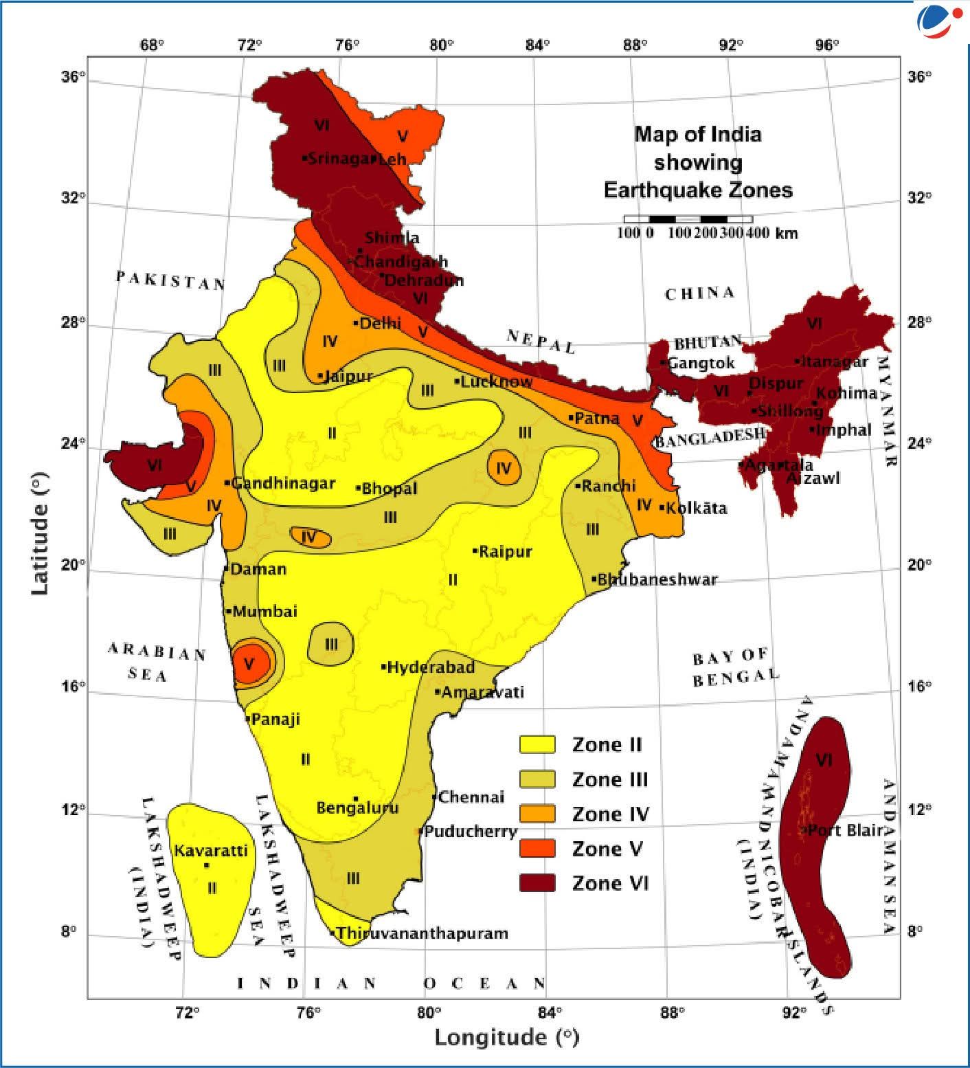
In a move that made national headlines in late 2025, India’s Bureau of Indian Standards overhauled the country’s seismic hazard map for the first time in over two decades. Under the revised Earthquake Design Code, a brand-new category — Zone VI — was created, representing the most extreme level of earthquake risk ever officially recognised in India. The entire Himalayan belt, stretching from Jammu and Kashmir in the west to Arunachal Pradesh in the east, was placed squarely in this category.
For Sikkim, this meant a jump from the earlier Zone IV classification to the top of the danger chart. Scientists had long argued that Zone IV vastly underestimated the risk. The new assessment, based on advanced probabilistic modelling of fault behaviour, stress accumulation patterns, and plate motion data, finally brought the official classification in line with geological reality.
The Director of the Wadia Institute of Himalayan Geology noted that the Himalayan belt remains fundamentally vulnerable, and the Zone VI designation offers a more honest picture of what could happen — and how damaging it could be. The revised code now requires structures in this zone to be engineered for forces roughly 50 to 60 percent greater than what the old standards demanded.
WHAT REPEATED SHAKING DOES TO FRAGILE MOUNTAINS
Most public attention focuses on the big quake — the one that topples buildings and makes headlines. But geologists warn that the quieter, smaller tremors may be doing damage that is just as consequential, only far less visible.
Sikkim sits on geologically young terrain shaped by the collision of the Indian plate grinding northward into the Eurasian plate at roughly five centimetres per year. The rock beneath the surface — primarily schist, gneiss, phyllite, and quartzite — is threaded with fault lines, including the Main Boundary Thrust, Main Central Thrust, Teesta Fault, and Gangtok Lineament.
When tremors ripple through this terrain repeatedly over months and years, they do not simply pass and leave things as they were. Each vibration opens tiny new fractures in the rock. Existing cracks widen. The bonds holding layers of metamorphic rock together gradually loosen. Slopes that were once marginally stable inch closer to collapse. When the monsoon arrives — and Sikkim receives an annual average of over 2,500 millimetres of rain, with some zones exceeding 5,000 millimetres — water seeps into these freshly opened cracks, and the result can be catastrophic.
This is how continuous tremors turn a mountain into a hazard. Not with a single dramatic blow, but through slow, cumulative erosion of the ground’s ability to hold itself together.
THE LANDSLIDE EQUATION
Roughly 69 percent of Sikkim’s total area is classified as landslide-prone. That means nearly seven out of every ten square kilometres of the state are at risk of earth movement. Settlements, roads, schools, and markets sit on ground that has been sliding, settling, and shifting for decades.
The 2011 earthquake set off landslides that buried stretches of the national highway, cutting off the state entirely and delaying rescue operations for days. The October 2023 glacial lake outburst flood from South Lhonak Lake, which sent a devastating surge of water and sediment down the Teesta valley and destroyed the Chungthang hydropower dam, was made worse by the fact that surrounding slopes had already been destabilised by years of tremor activity. The rock along the river corridor, predominantly weak phyllite formations, had been subjected to repeated shaking and cyclical wetting and drying that left it barely holding together.
Unplanned road construction has compounded the problem. Across Sikkim, new roads have been carved into hillsides under various government schemes without proper geological assessments or drainage planning. The exposed, unsupported cuts create fresh weak points that tremors and rain exploit ruthlessly.
BUILDINGS, BRIDGES, AND A CYCLE OF DAMAGE
Every structure in Sikkim — every home, hospital, school, bridge, and tunnel — absorbs the energy of each passing tremor. A building that survives one moderate earthquake may develop invisible stress fractures. Concrete weakens. Steel reinforcement corrodes faster where cracks let moisture in. Foundations shift on uneven, loosened ground. Over time, structures that appear intact from the outside may be dangerously compromised within.
This is especially worrying in older parts of Gangtok and other towns where buildings were constructed long before modern seismic codes existed. After the 2011 disaster, reconstruction began, but subsequent tremors in 2016, 2017, 2023, and 2024 kept undoing progress. The cycle of damage, repair, and fresh damage has become a defining feature of life in Sikkim.
The new Zone VI standards require hospitals, schools, bridges, and essential pipelines to remain functional even after a severe earthquake. Heavy fittings such as water tanks, facades, and ceiling panels must be securely anchored. These are sensible mandates, but enforcing them across thousands of existing structures in a mountainous state with limited administrative capacity is a monumental task.
AN ECONOMY THAT SHAKES WITH THE GROUND
Three pillars hold up Sikkim’s economy: tourism, agriculture, and hydropower. All three buckle when the ground moves.
Tourism is Sikkim’s showpiece. The state draws visitors from across India and the world with its mountain scenery, monasteries, and trekking routes. But tourism runs on confidence. When news of earthquakes spreads, bookings evaporate. When landslides sever road access — as they have done repeatedly on the state’s arterial highways — the flow of visitors stops entirely. After the 2011 earthquake, it took Sikkim years to rebuild its reputation as a safe destination. Each new round of tremors chips away at that hard-won recovery.
Agriculture, already constrained by the limited availability of flat land, suffers when landslides swallow terraced farms, divert irrigation channels, or bury crops under debris. For rural families dependent on small plots, the loss is not abstract — it is the difference between sustenance and hardship.
Hydropower tells perhaps the starkest story. Sikkim has invested heavily in damming the Teesta and its tributaries. But the track record of seismic and flood damage to these projects raises hard questions. The 2011 earthquake killed workers at a hydroelectric site. The 2023 flood obliterated the Chungthang dam. In 2024, a landslide struck the Teesta V power station at Balutar. Building and rebuilding expensive energy infrastructure in a zone that shakes this frequently is not just an engineering challenge — it is a question of whether the strategy itself is sustainable.
THE TOLL ON MINDS AND COMMUNITIES
Numbers capture the physical damage, but they miss the quieter devastation. People in Sikkim’s tremor-affected districts live with a constant undercurrent of dread. Sleep is disrupted. Anxiety spikes with every mild vibration. Families who endured the 2011 tragedy find old trauma resurfacing each time the walls tremble.
Children in these areas are growing up treating earthquakes as a routine part of life — a normalisation of danger that child psychologists say can shape anxiety patterns well into adulthood. Temporary evacuations, even when precautionary, pull children out of school, separate families, and disrupt healthcare routines.
In small rural communities, where a single road may be the only connection to the outside world, a landslide triggered by cumulative seismic weakening can mean weeks of isolation. The social bonds that hold these communities together fray under repeated disruption.
THE SHADOW OF THE BIG ONE
Beneath the conversation about continuous small tremors lies a far more unsettling possibility. The Himalayan belt has produced catastrophic earthquakes throughout recorded history — events of magnitude 8.0 and above that reshape entire landscapes. Seismologists have identified stretches of the Main Himalayan Thrust where no major rupture has occurred for centuries, meaning that colossal amounts of strain energy remain locked underground, waiting to be released.
The smaller tremors Sikkim is currently experiencing do not release enough energy to meaningfully reduce this accumulated stress. Some researchers suggest that the ongoing seismic activity may in fact signal that stress is being redistributed along fault networks — potentially bringing certain locked segments closer to their breaking point.
Nobody can predict when or where a great Himalayan earthquake will strike. But the scientific community broadly agrees that the question is not whether such an event will happen, but when. For a state already reeling from the cumulative toll of years of persistent shaking, the implications are sobering.
THE PATH FORWARD
Acknowledging the danger is the first step. India took that step by creating Zone VI and placing Sikkim in it. But paper classifications do not reinforce concrete walls or stabilise crumbling hillsides. What follows must be action — urgent, sustained, and adequately resourced.
Every public building, hospital, school, and bridge in the state needs a thorough seismic safety evaluation. Those that fall short of the revised standards must be strengthened or replaced. New construction must meet Zone VI specifications without exception, and local enforcement agencies need the authority and resources to ensure compliance.
Seismic monitoring infrastructure must expand beyond its current footprint. Real-time data from the ground needs to reach citizens as actionable warnings, not just scientific records. Community-level preparedness — knowledge of evacuation routes, basic first-response skills, awareness of safe construction methods — must be embedded as a permanent programme in every district.
Most critically, the way Sikkim plans its growth must change. Roads carved recklessly into unstable slopes, settlements perched on riverbanks, and massive dam projects in shaking valleys all need to be reassessed against the reality of what Zone VI means. Development that ignores geology is not development — it is a gamble with lives.
Sikkim’s mountains are among the most breathtaking on earth. They are also among the most dangerous. The tremors that have become a fact of daily life in the state are not benign rumbles. They are warnings — delivered by the planet itself — that the ground here is alive, restless, and unforgiving.
The people of Sikkim deserve more than sympathy after each earthquake. They deserve infrastructure that can withstand the next one, governance that plans for the worst, and a development philosophy that respects the violent forces shaping the land they call home.
The shaking will not stop. Preparation must not either.