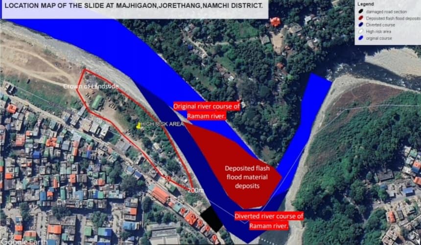
A team of Geologists from Mines and Geology Department, Government of Sikkim, Gangtok visited the landslide area of Jorethang on 30/06/2023. On Preliminary geological inspection the following observations are made:-
The slide area is located at N270 07.896’ latitudes E88016.774’ longitudes at an elevation of 325m amsl. The slide is located approximately 200 meters south of Green Lung Park along Circular road at Majhigaon, Jorethang, Namchi District (valley side). Further, the slide is located opposite to the confluence of Ramam khola and Rangit khola in the area The area is part of river terrace comprising of River Borne Material (RBM) deposits represented by boulders, cobbles, pebbles overlain by sandy soil overburden. The lithology of the area is sedimentary rock represented by dolomitic limestone with sandstone.
Causes of the landslide:
1. Toe cutting by Rangit and Ramam River

The main triggering factor for Majhigaon Landslide was toe cutting by the river which experienced a flash flood in the Ramam khola on 28th June 2023 and eroded the base of slope of the Circular Road formation. The course of Ramam river flow was diverted by 100m (approx.) due to accumulation of flash flood material deposits on the mouth of Ramam river hence, pushing the Rangit river towards the left bank of the river. The increase in volume of the water in Ramam khola may be due to incidences of bank erosion/slide/dumping of construction muck materials along the catchment area.
2. Geological characteristics of the damaged road formation:
The road formation was built on loosely compacted filling materials which on interaction with high flash flood led to sudden failure of the base of the road formation. The filling materials possess very low shear stress which is highly susceptible to failure leading to slide. The road formation of approximately 20 meters has been washed out/severely damaged. Cracks can be observed on the road formation as well of the existing buildings in the hill side of the slide. Looking at the severity and caving on the edges of the damaged road formation the occupants of 5 nos of building to be immediately evacuated.
The chances of migration of landslide towards the upslope area is very high.
Suggestions:
1. The damaged road formation of approximately 20 meters is constructed over loosely compacted filling materials underlain by river borne material deposits. Hence, chances of migration of the slide towards the upslope area are high as no bed/country rock is exposed along the slide area.
2. Due to proximity to slide to the houses i.e. approximately 5 meters and development of hairline cracks on the building located on the hill side of the road section chances of severe damages/collapse cannot be ruled out in immediate future. Therefore, occupants of the 5 nos of building to be immediately shifted to a safer location.
3. Gabion walls to be constructed along the damaged road section as a temporary measure so that the rate of toe erosion by the khola can be minimized especially during heavy rainfall. Covering by tarpaulin of the entire slide area is suggested to avoid seepage of rainwater through cracks developed on the road section in the area.
4. The building located on the valley side along with temporary shelters to be kept at high alert or shifted to a safer location as the changed

river course may cause damage especially during heavy rainfall. Further, the changed river course may erode the left bank comprising of loosely compacted RBM deposits which is also a threat to the settlements in the valley side of road section area.
5. Collection of the deposited flash flood material can be done during the dry seasons so that the original course of the Ramam khola is retained. Further, in the catchment area dumping of muck along streams, river banks to be avoided which increases the volume of runoff during monsoon by several times and results in such flood situations in the downstream area.
I
6. Detailed Geological investigation is suggested to restore the road formation during the dry seasons so that the footing of the foundation of the wall of the road formation may be done on competent strata/bed rock in the area. Further, deep type foundations such as piling are suggested as a permanent mitigation measure followed by bank protection works with placement of big stone boulders.
For breaking news and live news updates, like us on Facebook fb.com/thevoiceofsikkim or follow us on Twitter twitter.com/thevoicesikkim and Instagram instagram.com/thevoiceofsikkim. Visit www.voiceofsikkim.com.


